Trail Touring skiing Le Dévoluy - La Rama 2379m. Le Chauvet - Photo
 nadd73
nadd73

User GUIDE

© OpenStreetMap contributors
Length
Length
14.1 km
Max alt
Max alt
2353 m
Uphill gradient
Uphill gradient
1443 m
Km-Effort
Km-Effort  
33 km
Min alt
Min alt
1396 m
Downhill gradient
Downhill gradient
1443 m
Boucle
Boucle
Yes
Creation date :
2020-02-13 07:53:02.608
Updated on :
2020-02-13 17:02:14.982

(0 Reviews)

Touring skiing
Touring skiing
7h00
Difficulty : Medium

Scan this QR Code to open this trail in the SityTrail application

FREE GPS app for hiking

Logo SityTrail SityTrail

IGN / Geographical institutes

Download SityTrail from the App Store Download SityTrail from Google Play

Logo SityTrail SityTrail World

The world is yours!

Download SityTrail from the App Store Download SityTrail from Google Play Download SityTrail on Huawei AppGallery

About

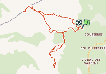
Trail Touring skiing of 14.1 km to be discovered at Provence-Alpes-Côte d'Azur, Hautes-Alpes, Le Dévoluy. This trail is proposed by nadd73.

Description

Départ Courtière, les Crises.
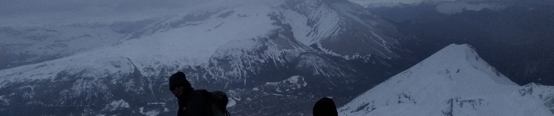
Couteaux utiles car neige dure.
Et crampons pour l'arête de La Rama.

Elevation profile

Photos

Positioning

Country:
France
Region :
Provence-Alpes-Côte d'Azur
Department/Province :
Hautes-Alpes
Municipality :
Le Dévoluy
Location:
Agnières-en-Dévoluy
Start:(UTM)
725998 ; 4950725 (31T) N.

Trails nearby

Trail Walking Le Dévoluy - R13   Le Col de Lauteret - Photo
Walking
GUIDE+

Walking

Medium
(1)
Le Dévoluy, Provence-Alpes-Côte d'Azur, Hautes-Alpes, France
8.5 km | 15.9 km-effort
3h 12min
Yes
Trail Walking Le Dévoluy - R12   Le Col des Aiguilles - Photo
Walking
GUIDE+

Walking

Medium
(1)
Le Dévoluy, Provence-Alpes-Côte d'Azur, Hautes-Alpes, France
10.2 km | 19.2 km-effort
3h 56min
Yes
Trail Walking Le Dévoluy - R11   Cabane Rama - Photo
Walking
GUIDE+

Walking

Very easy
(4)
Le Dévoluy, Provence-Alpes-Côte d'Azur, Hautes-Alpes, France
5.5 km | 8.4 km-effort
1h 46min
Yes
Trail Walking Le Dévoluy - Cascade de Saute Aure - Photo
Walking
marmotte83

Walking

Easy
(3)
Le Dévoluy, Provence-Alpes-Côte d'Azur, Hautes-Alpes, France
7.7 km | 10.8 km-effort
3h 1min
Yes
Trail Walking Le Dévoluy - suuntoapp-Hiking-2024-06-17T07-23-45Z - Photo
Walking
GUIDE
Marco05

Walking

Difficult
Le Dévoluy, Provence-Alpes-Côte d'Azur, Hautes-Alpes, France
9.6 km | 17.9 km-effort
4h 4min
Yes
Trail Walking Le Dévoluy - Tête de Garnesier - Photo
Walking
GUIDE
Marco05

Walking

Very difficult
Le Dévoluy, Provence-Alpes-Côte d'Azur, Hautes-Alpes, France
11.5 km | 26 km-effort
5h 57min
Yes
Trail Walking Le Dévoluy - Maniboux - Photo
Walking
GUIDE
Marco05

Walking

Medium
Le Dévoluy, Provence-Alpes-Côte d'Azur, Hautes-Alpes, France
10.9 km | 16.9 km-effort
3h 49min
Yes
Trail Walking Le Dévoluy - Col des Aiguilles - Photo
Walking
GUIDE
Marco05

Walking

Difficult
Le Dévoluy, Provence-Alpes-Côte d'Azur, Hautes-Alpes, France
11.3 km | 21 km-effort
4h 46min
Yes
Trail Walking Le Dévoluy - Cabane de la Rama - Photo
Walking
GUIDE
Marco05

Walking

Easy
Le Dévoluy, Provence-Alpes-Côte d'Azur, Hautes-Alpes, France
5.8 km | 8.6 km-effort
1h 56min
Yes


Close
My subscriptions